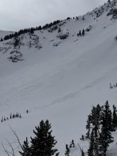
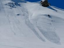
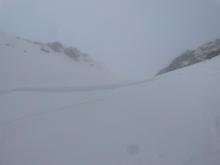
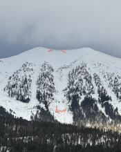
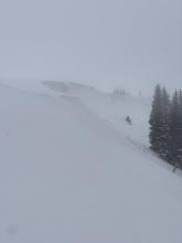
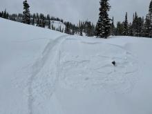
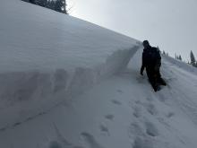
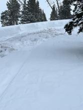
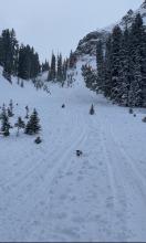
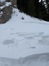
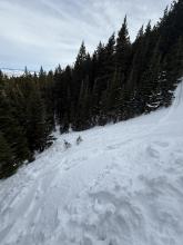
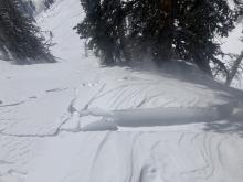
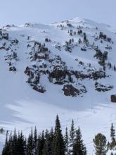
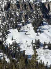
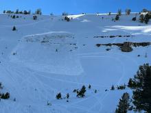
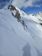
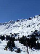
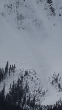
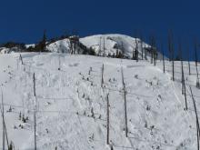
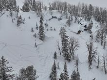
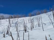
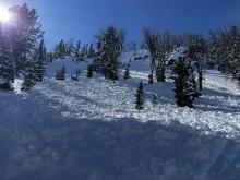
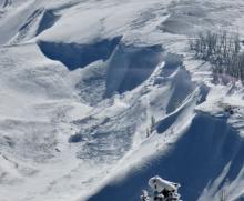
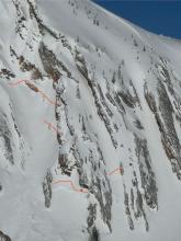
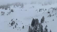
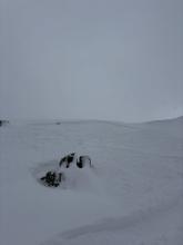
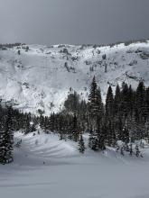
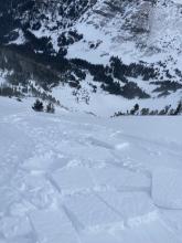
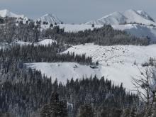
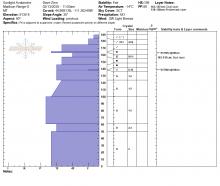
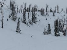
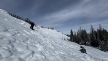
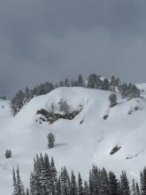
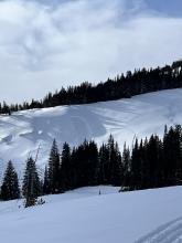
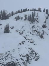
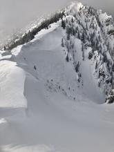
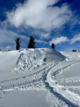
Avalanche Activity
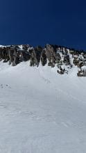
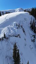
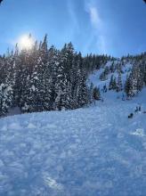
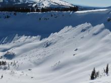
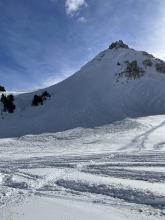
WL-AS-R2-D1.5
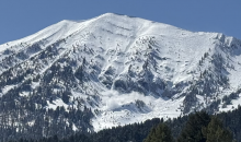
Elevation: 7,800
Aspect: E
Coordinates: 45.8156, -110.9230
Caught: 0 ; Buried: 0
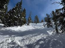
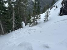
From obs. “We were above the entrance to Exit Chute and triggered a slough slide that slid down one of the gullies that emptied into PK bowl. It appears to have followed an existing slide path, terminating in the top of what looked to be a significant existing avalanche runout. The slide looks pretty wide but not deep.”
More Avalanche Details


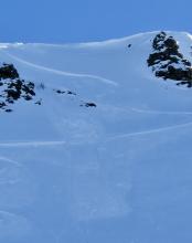
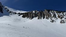
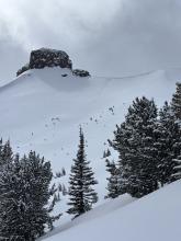
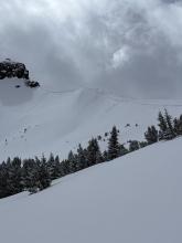
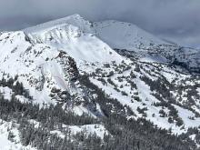
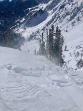
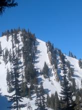
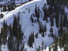
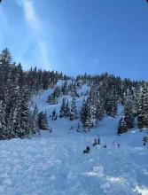
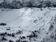
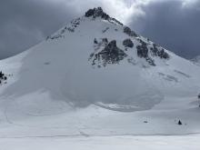
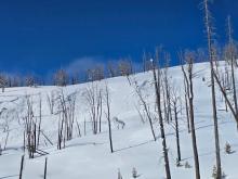
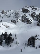
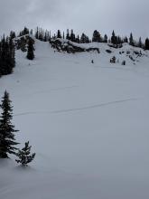
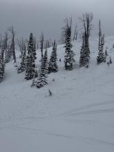
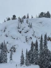
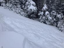
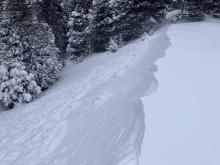
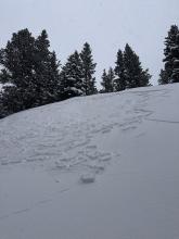
WL-N-R2-D2
Elevation: 8,000
Aspect: E
Coordinates: 45.8084, -110.9300
Caught: 0 ; Buried: 0
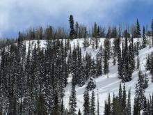
From obs.: “Saw many recent looking wet loose avalanches on east facing slopes at Bridger. We got a good look at the debris pile from one in Z chute and it looked big enough to bury a person (D2) and had run far past the cat track into south bowl.
We encountered a lot of variation in ski penetration with ~1' of loose melt forms in places on north and east facing slopes ~8k' in elevation.”
More Avalanche Details
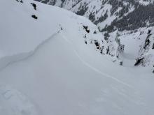
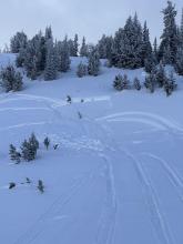
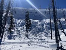
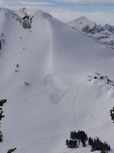
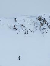
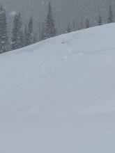
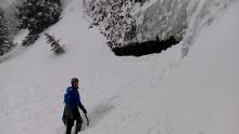
SS-AS-R1-D1-I
Elevation: 10,200
Aspect: NE
Coordinates: 45.0722, -109.9280
Caught: 0 ; Buried: 0
Near Cooke City on 4/19 skiers triggered a dry loose avalanche and a small wind slab avalanche. The wind slab broke in a drifted pocket near the base of cliffs, 3-6" deep x 10' wide. Northeast aspect, 10,200'.
More Avalanche Details

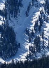
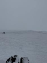
SS-AS-R1-D1-I
Elevation: 7,700
Aspect: NE
Coordinates: 45.9196, -110.9760
Caught: 0 ; Buried: 0
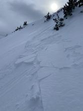
Today (Saturday, 4/19), I triggered a small soft-slab avalanche at about 7,700' on a E-NE aspect on the headwall between Frazier Lake and Angier Lake in the northern Bridgers. The slide was maybe 6" deep, 20' wide and ran 100-200 feet and involved only the new storm snow over the icy, thick crust underneath. No one was caught or injured, though I had a bit of a scare because my dog was right in the path (luckily she outran it). We had gone up with the intention of skiing the Ainger "Love Chutes", but bailed partway up when that whole aspect turned out to be breakable crust. However, we had beta from another party that conditions on the Frazier-Angier headwall were good, so decided to check that out. We skinned up without incident, following a well-set skin track that followed the line of least resistance; snow surface was variable but seemed stable. Coming down, we mostly followed the ascent route, but towards the end I was tempted onto a fun-looking, untracked stash a bit to skier's left, that seemed only a tad steeper than the ascent line. A few turns into this line is when I triggered the slide, right at the steepest part (mid-high 30s). It definitely took me by surprise given that we'd been skiing great, stable powder in the Bridgers the past couple days. No harm done but definitely a good wake-up call!
More Avalanche Details


WL-N-R1-D1
Coordinates: 45.9043, -110.9580
Caught: 0 ; Buried: 0
Meant to submit this yesterday (4/18), saw this one wet loose slide that naturally started off some rocks. Decent size by the bottom. Other than that, just some spiff. Surprisingly didn’t see any big wind slabs trigger, despite the widespread wind effect in the northern Bridger’s. Lots of wind scour on southerly aspects. Northern aspects had wind loading.
More Avalanche Details

SS-N-R2-D2-I
Coordinates: 45.0202, -109.9380
Caught: 0 ; Buried: 0
I rode the motorized zone and noticed natural wind slab avalanches running pretty far on: East Henderson, SE Scotch Bonnet, East Miller, NE Crown Butte. D1.5-2.0
Loose wet debris from yesterday were also present in many places.
More Avalanche Details
WL-N-D1
Coordinates: 44.9952, -109.9080
Caught: 0 ; Buried: 0
Today I was skiing in East Hayden Creek. I witnessed a cornice fall around 1230pm. Also I triggered multiple wet loose avalanches on several aspects including a north facing slope 9400 ft. None bigger than D1
More Avalanche Details
Caught: 0 ; Buried: 0
Found some reactive fresh windslabs that were on northeast terrain features yesterday Wednesday 4/9 easily triggered with a very small cornice we dropped in the northern Madison range, the pocket slabs didn’t propagate super wide but did pack a punch and were up to 1 ft deep.
More Avalanche Details
SS-N-R1-D1-I
Elevation: 9,000
Aspect: SE
Coordinates: 45.9043, -110.9580
Caught: 0 ; Buried: 0
I rode into Fairy Lake. There was 2-3” of new snow above the elevation of Fairy Lake, a trace below. Winds were cranking at ridge top elevation, transporting what soft snow there was. Minimal hazard formation. I spotted one fresh wind slab avalanche near Hardscrabble. The slide ran several hundred feet in steep terrain but was very thin (R1,D1).
There was a mostly supportable crust below the new snow about 1” thick. The snow below the crust was moist.
More Avalanche Details
SS-ASc-R1-D1
Elevation: 9,800
Aspect: N
Coordinates: 45.0471, -109.9990
Caught: 0 ; Buried: 0
Today A Skier triggered a 6”x20’ wide wind slab on a N aspect at 9,800’.
More Avalanche Details


WL-ASc-R1-D1.5-O
Elevation: 1,000
Aspect: SE
Coordinates: 45.0202, -109.9380
Caught: 0 ; Buried: 0
Skiers triggered D1-D1.5 wet loose on SE aspect at 10,000’.
There were also natural small wet loose slides today and yesterday. Long running, but narrow, in steep terrain. Typically initiated near rock outcrops.
Today was hotter than yesterday and the top of the snowpack got pretty wet before clouds built in the afternoon. Snow stayed dry on due north up high.
More Avalanche Details

WL-NC-R1-D1-S
Elevation: 10,000
Aspect: E
Coordinates: 44.9952, -109.9080
Caught: 0 ; Buried: 0
While touring south of town today, we observed two D1 wet loose avalanches on an east aspect at 10000’. Both occurred at 11am and were triggered by a small cornice fall due to rapid warming.
More Avalanche Details
L-N-R1-D1.5
Elevation: 8,500
Aspect: E
Coordinates: 45.7701, -110.9400
Caught: 0 ; Buried: 0
Observed multiple D1-1.5 natural dry loose avalanches (and some tiny wind slab pockets under the ridge cornice) that likely occurred during peak warming around 2-3 PM. North/sheltered aspects from ~9- 8.5k held an average of 8+ inches of dry, drifted snow. Early AM to mid-afternoon, very active wind transport followed by tapered winds and a rapid increase in temp.
More Avalanche Details
Coordinates: 45.0524, -109.9450
Caught: 0 ; Buried: 0
We saw a couple 3-6" deep natural wind slab avalanches and a few dry loose slides that looked to have happened within the last 24 hours. On southerly slopes below 9,000' there were some wet loose slides from yesterday afternoon.
More Avalanche Details
HS-AS-R1-D1-S
Elevation: 9,800
Aspect: NE
Coordinates: 45.0524, -109.9450
Caught: 0 ; Buried: 0
Wind slabs were still reactive today. We triggered 3 small, 3-8" deep x 5-15' wide, hard wind (1F+) slabs on convex test slopes well below the main ridgelines. 9,800', NE aspects. Also triggered one softer (4F) wind slab just below the high ridgeline, 10,200', NE aspect. 10-15' wide x 6-8" deep.
More Avalanche Details
AS-R1-D1.5
Elevation: 9,000
Aspect: E
Coordinates: 45.8926, -110.9620
Caught: 0 ; Buried: 0
We went on a tour in the Bridgers today, we ascended the east ridge of Naya Nuki to the entrance of the Great One. Wind was blowing and we were being careful about potential wind slabs up high.
Skier 1 ski cut the top of the chute and produced a small wind slab that ran to the break in the chute and continued another 100 vert down the east apron. After all meeting up halfway down, skier 2 proceeded to ski the E facing apron. A wind slab propagated and carried skier 2 roughly 300 vert down the apron where skier 2 was able to swim out of the fall line and came to a rest on top of the debris. Everyone was okay aside two missing ski poles.
On the way out, we saw a few more small natural wind slabs that broke naturally near ridge lines as well as point and release wet slides.
More Avalanche Details
Elevation: 8,800
Aspect: E
Caught: 0 ; Buried: 0
A snowobarder tagged us in an IG story of triggering a long running, powerful wet loose slide in the Bridger Range.
More Avalanche Details
AS-R1-D1.5-I
Elevation: 9,000
Aspect: NE
Coordinates: 45.7943, -110.9360
Caught: 0 ; Buried: 0
From BBSP: " At 2.45?pm a... solo skier triggered a wind loaded pocket on the main face of Saddle Peak that ran down over the cliff and produced an impressive powder cloud.... I met him... and confirm he was alone and no one was in front of him. The avalanche looked to be 2' deep on the southern flank and 5" deep on the northern flank... It entrained more snow on the way down, one 2' deep downhill wind loaded pocket and some loose wet snow. It ran into the bottom of the going home chute, gouging a large hole and then 100ft downhill left a 200ft by 30ft wide shallow debris pile."
More Avalanche Details

SS-ASc-R1-D1-I
Elevation: 10,100
Aspect: N
Coordinates: 45.0202, -109.9380
Caught: 0 ; Buried: 0
Wind slab near Cooke City from yesterday. Intentionally triggered. North aspect, 10,100'. 1' deep, 20' wide.
More Avalanche Details
AS-R1-D1-S
Elevation: 9,000
Aspect: NE
Coordinates: 45.7943, -110.9360
Caught: 0 ; Buried: 0
I was skiing in bounds on Slushman’s lift and saw a pair of R1, D1 avalanches on Saddle Peak. One appears to be a loose snow avalanche triggered by a skier coming off of north Saddle Peak That ran a couple hundred feet. The second was a small slab coming out of Spencer’s with debris running into Going Home Chute.
There were many tracks across the visible Saddle Peak terrain.
More Avalanche Details
SS-ASu-R1-D1-S
Elevation: 9,280
Aspect: N
Coordinates: 45.0027, -109.9170
Caught: 0 ; Buried: 0
Ice Cream Scoop on Skiers Left Side in Gully, North Aspect, 9280'
SS-ASu-R1-D1-S
One of the few spots on the gully where there are no trees as a wind block on the skiers left (south) side. Noticed a few cornices on south side of gully where it is exposed to W/SW/S winds. Skier took a left turn under cornices to scrub speed and released a 6-10" windslab 40' wide which ran 10' at most. Super soft and easy to ski through.
More Avalanche Details
SS-ASu-R1-D1.5-S
Aspect: E
Coordinates: 45.3453, -111.3750
Caught: 0 ; Buried: 0
Skied around Beehive Basin today; there was lots of new snow and very little wind effect. Skied into the top of Bear Basin from Beehive by going up going home and down the east side, right-side-up powder skiing. While descending Island Boy into the South Fork of Spanish Creek, we had similar 60-100 cm of right-side-up new snow on a heavily textured melt-freeze layer of old snow. Felt the snow density stiffen up from light low density snow around 300 meters down the ski line so cut to the left into a safe zone, the slope at the my skis broke about 15-20 meters wide and 15 cm deep at the flanks to 40cm deep in the gut, SS-ASu-R1-D1.5-I-M(L)-TK. About 30 meters downhill, the slab rode up onto the new snow and ran out of momentum before reaching the runout. Right where the slope broke, we had wind wrapping around the north ridge cross-loading the couloir (skiers left to right), downslope, and on skiers' right of the line, there was no evidence of wind transport. Skied the rest of the line and looped back into Beehive with no other excitement.
More Avalanche Details
SS-ASc-R2-D1.5-S
Elevation: 9,600
Aspect: N
Coordinates: 45.0202, -109.9380
Caught: 0 ; Buried: 0
From email: "Ski touring near Cooke City today we intentionally triggered a storm slab/ wind slab on a steep north aspect around 9600'. It was about 6" deep, and 30' wide."
More Avalanche Details
WL-AS-R1-D1.5-I
Aspect: E
Coordinates: 45.7943, -110.9360
Caught: 0 ; Buried: 0
Heavy, wet slide of recent snow released while skiing off South Saddle.
More Avalanche Details
L-AS-R1-D1.5-S
Elevation: 8,400
Coordinates: 45.9043, -110.9580
Caught: 0 ; Buried: 0
Skied the north chutes above fairy lake around 8,400 ft. Found 8-12" of new snow, with the bottom 2" consisting of large graupel. In steep terrain our sluff entrained lots of snow making for some large debris piles. Overall the snow was generally well bonded.
More Avalanche Details
AS
Elevation: 8,300
Aspect: N
Coordinates: 45.8822, -110.9520
Caught: 0 ; Buried: 0
The skiing was good and non reactive on the main East face next to the skin track. The North gullies into Naya Nuki creek and the the lower/steeper gullies to the south were highly reactive and entraining lots of snow.
More Avalanche Details
SS-AS-R1-D1-S
Elevation: 8,500
Aspect: NE
Coordinates: 45.8586, -110.9560
Caught: 0 ; Buried: 0
Skied the Banana today with 8-12” of new snow that has mostly bonded. The snowpack below the new snow had froze over night and was well consolidated.
Observed a layer of graupel (3-4mm grains) at the new/old interface on the NE ramp starting at 8600’ and clearing up after 8700’. This layer created some reactivity in the storm snow.
Wind slabs <6” had formed on N and NE aspects. We had one small release in the bottom of the couloir measuring ~10x20’ and running ~50’.
More Avalanche Details
WL-N-R1-D1.5
Coordinates: 45.3407, -111.3910
Caught: 0 ; Buried: 0
Toured around Beehive and Middle Basins this morning, finding predictably bulletproof snow on most aspects but decent turns aided by the 2-4 inches of snow from last night on northerly terrain that hadn’t been destroyed by the sun this week. There were a few brief moments of direct sun throughout the morning, which almost instantaneously triggered point releases from steeper rocky terrain. On the way back through Beehive we observed some much larger debris piles that weren’t there this morning from the steel rocky face between the Going Home chute and the prayer flags.
More Avalanche Details
WL-N-R1-D1-I
Elevation: 8,500
Coordinates: 45.9043, -110.9580
Caught: 0 ; Buried: 0
We rode up to Fairy Lake area today and quickly found out just how warm it has been in this area the last two days. At the trailhead at 10am temperatures were around 47 degrees. Last night, it did not freeze below 9000' and an isothermic snowpack now exists from the trailhead all the way to Fairy Lake and above, until you pop out into Airplane Bowl. When we returned to the trailhead around 2:30pm, it was 65 degrees at the truck.
While higher elevation southerly and easterly snowpacks were warm and wet, free water was only moving through the upper few inches of the snowpack by 1pm. High elevation northerly aspects remained colder and more locked up than we expected given the ambient air temperature. Winds were light from the W and were doing little to keep surfaces cold.
There were a number of wet loose avalanches in Airplane Bowl when we were heading out around 2pm. All on E/S aspects near rocks or cliffs. Most were relatively small and had not entrained much snow from the surface or gouged deeper than a few inches.
On the drive back to town, we noted 5 or so larger wet loose avalanches in Argentina Bowl, with a good number of smaller slides at different points along the ridge
Seeing as it is now the season for wet snow hazards, there are a few things that are critical to consider: aspect, elevation, and timing.
Timing your day to be off of steep slopes before melt water percolates too deep and destabilizes the slope is key, AND making sure to account for steep low-elevation slopes that you may have to pass through on your way back to the trailhead. If you start to sink in deeper than your ankles, or your sled track is digging into slush, that means it is time to either shift to colder aspects or head back to the trailhead.
Our greatest concern with these wet loose avalanches is not so much their size, but their power to push you into terrain traps like cliffs, gullies, trees, or rocks. The two scenarios when we are most concerned about these avalanches are when new snow gets wet and sheds for the first time OR when there have been multiple days without a solid refreeze and melt-water percolates deep into the snowpack.
More Avalanche Details
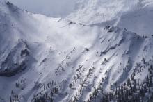
WL-N-R2-D2
Aspect: S
Coordinates: 45.3690, -111.1750
Caught: 0 ; Buried: 0
In Gallatin Canyon we saw some wet slides in the chutes/gullies south of Lava Lake
More Avalanche Details
SS-N-R1-D1-I
Elevation: 10,000
Aspect: NE
Coordinates: 45.0524, -109.9450
Caught: 0 ; Buried: 0
Today we noticed these natural small wind slabs on Mt Henderson.
More Avalanche Details

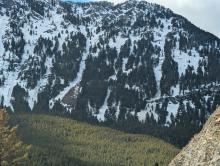
WS-N-R1-D1-I
Elevation: 8,000
Aspect: SE
Coordinates: 45.8322, -110.9280
Caught: 0 ; Buried: 0
We skied past a wet loose avalanche that came off of the south face of Bradley‘s Meadow. It was slightly bigger than the rest of the wet snow activity that I observed during the day.
More Avalanche Details
SS
Elevation: 9,100
Aspect: E
Coordinates: 45.7943, -110.9360
Caught: 0 ; Buried: 0
Noticed crown and debris on drive up Bridger Canyon this morning. Looks like a wind slab.
More Avalanche Details
SS-N-R2-D2-I
Elevation: 10,000
Aspect: E
Coordinates: 45.0046, -109.9580
Caught: 0 ; Buried: 0
We noted one avalanche on the Fin that likely occurred yesterday or early this morning from a wind slab or cornice fall.
More Avalanche Details
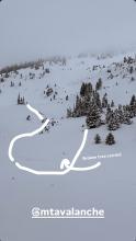
SS-N-R2-D2-O
Elevation: 9,000
Coordinates: 45.0202, -109.9380
Caught: 0 ; Buried: 0
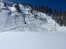
Photo of a recent natural avalanche north of Cooke City, observed today. A S, SE aspect in Sheep Creek at about 9000'. Seems like it likely occurred yesterday.
Estimated to be about 2' deep at 250' wide.
More Avalanche Details
SS-N-R1-D1
Elevation: 9,200
Aspect: N
Coordinates: 45.1719, -111.3800
Caught: 0 ; Buried: 0
We rode into all three Yellow Mule drainages and the head of Muddy Creek. It was snowing hard and wind was blowing strong this morning. In the afternoon, clouds lifted and snow let up. Skies remained mostly cloudy, but with high clouds there was decent visibility at the end of the day. There were 10-12" of new snow since last weekend, 2-4" low density fell this morning.
There was a small wind slab avalanche in McAtee (Photo) and a small wind slab in Beaver Creek.
More Avalanche Details
HS-AM
Elevation: 9,070
Aspect: N
Coordinates: 44.9442, -111.2850
Caught: 0 ; Buried: 0
Snowmobile triggered slide in Taylor Fork today from above cutting across. Nobody caught. 2.5 feet deep 150 feet wide
More Avalanche Details
SS-N-R1-D1-I
Elevation: 9,000
Aspect: E
Coordinates: 45.7943, -110.9360
Caught: 0 ; Buried: 0
It looked like there were several small wind slabs triggered on Saddle Peak. I was skiing with my family and didnt get a good look or a photo. One appeared to be just off the summit maybe 12" deep and not running very far at all. The other appeared to be near the going home chute even with the cliffs, and this one ran a bit further. These wind slabs looked like something to be looking for but also easy to avoid.
More Avalanche Details
SS-AM-R2-D2-O
Coordinates: 44.9731, -111.3100
Caught: 0 ; Buried: 0
From FB message. Today (3/19) in Taylor Fork
More Avalanche Details

SS-N-R2-D2-I
Elevation: 10,800
Aspect: E
Coordinates: 45.1153, -109.9140
Caught: 0 ; Buried: 0
Today we saw a D2 slab avalanche at Goose Lake, E facing, 10800 ft. We estimate this avalanche to have ran in the early hours of 3/17. This was the only avalanche we observed in the past 4 days.
More Avalanche Details
N-R2-D2-I
Elevation: 10,000
Coordinates: 45.0202, -109.9380
Caught: 0 ; Buried: 0
We rode the motorized zone today with Bill and noticed two slides. One on the SE face of Scotch Bonnet in Tragenic Bowl and one on the NE face of Wolverine. They both broke 2-4’ deep. The avalanche on Wolverine slide aprx 1500’. Both were in wind loaded areas at upper elevations. Ski cuts with snowmobiles were not producing avalanches in protected areas.
More Avalanche Details
SS-N-I
Aspect: E
Coordinates: 45.9043, -110.9580
Caught: 0 ; Buried: 0
Nature or cornice triggered slides in Arrowhead and Hardscrabble Bowls.
More Avalanche Details
N-R2-D2-I
Elevation: 9,400
Aspect: E
Coordinates: 44.7292, -111.3230
Caught: 0 ; Buried: 0
We saw many R1-R2 wind slab avalanches below the Lionhead Ridge cornice line. Visibility was limited so I won't estimate the exact number, but nearly every time we had good views of the steep faces, we saw cornice collapses, debris, or small crown lines. There were two slides on east aspects that ran closer to full path and piled debris more deeply. I expect that most of these had run within the last 24 hours, but continuing snowfall and hurricane force winds made precisely dating these a challenge (many trees were blown down during the wind event, these too were already somewhat buried). None of the avalanches broke on persistent weak layers as far as I could tell.
More Avalanche Details

SS-R1-D1-I
Elevation: 8,800
Aspect: N
Coordinates: 45.4444, -111.0040
Caught: 0 ; Buried: 0
On Sunday, skiers passed a small natural wind slab avalanche on the way down Blackmore that they didn’t see on the way up.
More Avalanche Details
SS-AS-R1-D1-I
Coordinates: 45.8512, -110.9480
Caught: 0 ; Buried: 0
From email: Isolated wind slabs today in the southern Bridgers.
More Avalanche Details

SS-AMc-S
Elevation: 9,000
Aspect: N
Coordinates: 45.1719, -111.3800
Caught: 0 ; Buried: 0
Up to a foot of soft snow which seemed to have included a few inches from last weekend. Winds were transporting snow across Buck Ridge all day long.
We triggered two small and shallow wind slabs that didn't go anywhere, but they were a warning of bigger wind slabs on bigger slopes. We didn't find any faceted or weak layers of concern in the snowpack.
Wind slabs will grow in size overnight and will be the main concern tomorrow. Fortunately they will be easy to see an avoid.
More Avalanche Details
L-AS-D1
Elevation: 9,300
Aspect: E
Coordinates: 45.0524, -109.9450
Caught: 0 ; Buried: 0
Today I triggered a D1 dry loose avalanche on a E facing 35 degree slope, 9300 ft on Mt Henderson. The new snow is very low density and is not bonding well to the old interface. I also observed some more dry loose activity/small wind slabs on Sheep Mt, NE facing, 10400 ft.
More Avalanche Details
L-AS-R1-D1.5
Coordinates: 45.7701, -110.9400
Caught: 0 ; Buried: 0
We traversed the ridge south from the Bridger Bowl ski area boundary to Bridger Peak...
Dry Loose avalanches (sluffs) ended up being the biggest hazard we encountered. The new snow (approximately 8") was easily sluffing over last weeks crust and was entraining significant volume and running far in steep terrain. It had plenty of power to knock you over or into trees/rocks.
More Avalanche Details
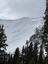
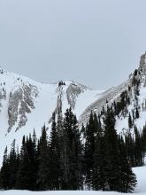
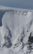
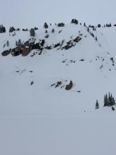
N-R1
Coordinates: 45.9233, -110.9800
Caught: 0 ; Buried: 0
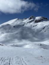
From obs: Winds in the Frazier Basin zone were stronger than expected with moderate to strong gusts at the ridge, increasing through the day.
We noticed two large windslab pockets that had released since yesterday’s snow. One at the base of Hardscrabble Peak on a N aspect, the other in one of the SE facing gullies that access the Peak 9299/Hollywood Headwall ridge (see photo).
More Avalanche Details
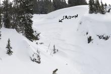
SS-N-R2-D2-U
Elevation: 9,600
Aspect: E
Coordinates: 45.0202, -109.9380
Caught: 0 ; Buried: 0
We were split boarding south of Cooke City today, up to terrain around 10'000', and finding good snow stability.
Weather was mostly cloudy in the am, partly cloudy in pm. Light winds from the SW.
No fresh avalanche activity observed. Attached is a photo of the only sign of a recent avalanche we could find. (an old crown on an East aspect at 9600').
More Avalanche Details
SS-AS
Coordinates: 44.9756, -110.0310
Caught: 0 ; Buried: 0
Found 5-8” of fresh low-medium density snow. Triggered multiple small soft storm slabs/sluff which occurred on steeper slopes (40+ degrees).
More Avalanche Details
HS-AMu-R2-D2-O
Elevation: 8,800
Aspect: NW
Coordinates: 44.9772, -111.2860
Caught: 0 ; Buried: 0
A group of riders saw Mark at the gas station and shared that they had triggered a 4' deep slide in a small pocket in Sunlight Basin of the Taylor Fork area. It was in an area with a relatively shallower snowpack, and broke on weak snow near the bottom of the snowpack. The rider that triggered it was going uphill and got stuck shortly after and noted the snowpack was much deeper there.
More Avalanche Details

L-N-R1-D1-S
Elevation: 9,500
Aspect: S
Coordinates: 45.0525, -109.9620
Caught: 0 ; Buried: 0
There was a small natural dry loose on south face of Crown Butte and I triggered a dry loose slide on a test slope near the ridge on Miller ridge (video).
More Avalanche Details

SS-N-D1
Elevation: 10,000
Coordinates: 44.9952, -109.9080
Caught: 0 ; Buried: 0
Today I observed multiple small wind slab avalanches off Woody Ridge. NE and E facing, 10000 ft. Max size D1. Also, there was many dry loose slides on Cooke Peak in Hayden Creek.
More Avalanche Details
SS-N-R1-D2-I
Elevation: 8,800
Aspect: N
Coordinates: 44.5602, -111.4630
Caught: 0 ; Buried: 0
We observed two very recent natural storm slab avalanches about a 1.5 feet deep. One of them entrained a significant amount of snow an ran a long ways.
More Avalanche Details

SS-N-R1-D1-S
Elevation: 9,000
Aspect: E
Coordinates: 44.7145, -111.3180
Caught: 0 ; Buried: 0
We rode out Lionhead Ridge and around the north end to the head of Targhee Creek. Skies started overcast, but cleared through the day as wind calmed from moderate to light out of the west and southwest.... there were two or three shallow small wind slabs below Lionhead Ridge.
More Avalanche Details
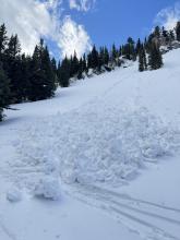
SS-AS-R2-D1.5-S
Elevation: 7,500
Aspect: NE
Coordinates: 45.9278, -110.9620
Caught: 1 ; Buried: 0
From obs: "Skier triggered wind slab on Northeast slope at 7,450 feet elevation. One skier was caught and carried roughly 10 feet before the slide came to a stop."
We also received reports from another group (IG story video) that triggered a couple similar sized wind slab avalanches in north facing chutes in Frazier Basin.
More Avalanche Details
L-N-R1-D1-S
Elevation: 8,500
Aspect: S
Coordinates: 45.8822, -110.9520
Caught: 0 ; Buried: 0
The new snow was low density and sluffed easily on steep shady northerlies. On steep slopes facing the sun (south and east, and probably west) the new snow sat on a crust and became moist as the sun warmed it up and started to slide under skis. We saw a couple very small natural loose snow slides below rock outcrops on south facing slopes. Air temperatures were well below freezing, especially with wind chill, but the sun quickly warmed the recent new snow.
More Avalanche Details
SS-ASc-R1-D1-S
Elevation: 8,300
Aspect: SE
Coordinates: 45.8822, -110.9520
Caught: 0 ; Buried: 0
There was 6" of low density snow from yesterday. Winds were stronger than expected, from the north at the top of the Throne, and increased through the morning.
We found fresh drifts that were reactive, cracking easily and 5-10' wide out from our skis, on south and east facing slopes around 8000-8300'.
More Avalanche Details
N-R1-D1
Coordinates: 45.4444, -111.0040
Caught: 0 ; Buried: 0
From obs: "Multiple natural loose avalanches in the steep terrain of mt Blackmore. All originated at the base of cliffs or trees. Counted 4 prominent ones"
More Avalanche Details
L-R1-D1
Coordinates: 45.4444, -111.0040
Caught: 0 ; Buried: 0
Saw lots of small loose avalanches on Mt Blackmore and nearby slopes, some appeared to be natural and others skier triggered. We saw multiple dry loose on N and E aspects and a wet loose on a southeast aspect.
We also noticed recent wind loading on the southeast side of ridgetops and scouring on north slopes.
More Avalanche Details
WL-N
Elevation: 9,500
Aspect: SW
Coordinates: 45.0423, -109.9650
Caught: 0 ; Buried: 0
Today we observed wet loose avalanches in steep, rocky terrain on the west side of Miller ridge. SW facing, 9500 ft
More Avalanche Details
WL-N-R1-D1.5
Coordinates: 45.0607, -111.2720
Caught: 0 ; Buried: 0
Another day of warm temps and clear skies allowed us to cover a lot of ground in the Southern Madisons. We rode into the Taylor Fork, up to the weather station, to the top of Carrot Basin, through Sage Basin, up and over into Cabin Creek, and all the way up to the head of Red Canyon.
There were a handful of small wet-loose avalanches on solar aspects that we noted throughout the day. While northerly aspects stayed cold, solar aspects became wet a couple inches down.
More Avalanche Details
C-N-R1-D1.5
Elevation: 9,000
Aspect: N
Coordinates: 45.4272, -111.0140
Caught: 0 ; Buried: 0
Pictures of two cornice triggered avalanches way up the South Cottonwood drainage that was viewed from Alex Lowe. Looks to be in the recent days, around 9,000 feet North facing.
Also a massive cornice that had cracked and was slowly making its way towards falling down. Cornice was around 50 feet long, and largely overhanging. On the standard ascent of the East Ridge of Alex Lowe, the skin track usually travels below this cornice while ascending to the ridge.
More Avalanche Details
WL-N-R1-D2
Aspect: S
Coordinates: 45.6553, -110.5580
Caught: 0 ; Buried: 0
Natural point release avalanche observed from the YC. Occurred out of bounds on the South side of Pioneer Mountain.
More Avalanche Details
WL-N-R1-D1
Coordinates: 45.8332, -110.9360
Caught: 0 ; Buried: 0
Observed multiple wet loose slides naturally triggering and running on south facing slopes beyond bradleys and on the south facing aspects of hourglass chute.
More Avalanche Details

C-ARc-R1-D2
Elevation: 9,100
Aspect: E
Coordinates: 45.3000, -111.3990
Caught: 0 ; Buried: 0
Kicked off a wind slab avalanche 25ft wide on the west ridge of beehive basin. The wind slab was around 8-10ft deep and the debris slid almost to the flat a few hundred feet down the slope. The slide occurred around 9100ft on the east aspect. Neither me nor my partner were carried or caught in the slide.
The windslab that broke off was about 8-10 feet tall. It was mostly a huge section of a cornice that broke and the slope it fell down onto seemed to propagate a few inches down as well. The majority of the debris was from the cornice.
More Avalanche Details
HS-AM-R1-D1-O
Elevation: 9,000
Aspect: N
Coordinates: 45.0607, -111.2720
Caught: 0 ; Buried: 0
Another day of warm temps and clear skies allowed us to cover a lot of ground in the Southern Madisons. We rode into the Taylor Fork, up to the weather station, to the top of Carrot Basin, through Sage Basin, up and over into Cabin Creek, and all the way up to the head of Red Canyon.
We spotted a few old avalanches. One in Cabin Creek that was triggered two days ago by snowmobilers on a N facing aspect. At the top of Carrot Basin, we saw a small avalanche (R1-D1) on a N aspect that likely broke yesterday on buried weak layers. We also spotted one cornice-fall triggered (R1-D2) avalanche that broke earlier this week in Sage Basin and then an older wind slab in Sunlight Basin.
More Avalanche Details
HS-AMu-R2-D2-O
Elevation: 9,100
Aspect: SE
Coordinates: 44.7250, -111.3220
Caught: 0 ; Buried: 0
Also, on our way out we saw an avalanche in Airplane Bowl that had been triggered during the day today. This slide also broke on the persistent weak layers, 2-3' deep, 150' wide.
More Avalanche Details
HS-AMu-R4-D3-O
Elevation: 9,200
Aspect: N
Coordinates: 44.7413, -111.3740
Caught: 0 ; Buried: 0
A rider triggered a huge avalanche in the uppermost reaches of Targhee creek. We discovered it on our way out. The best we could tell looking at their tracks was that they had no idea they triggered it, even though part of their tracks were swept away.
More Avalanche Details

SS-AMu-R1-D1-O
Elevation: 9,000
Aspect: N
Coordinates: 45.1719, -111.3800
Caught: 0 ; Buried: 0
In nearly 45 miles of riding, we noted two avalanches. Both breaking on persistent weak layers a few feet down in the snowpack. The first was a small north-facing pocket in the First Yellow Mule (R1-D1) that was snowmobile triggered. It looked to be around a week old. The second was a larger avalanche (R3-D2), east-facing, deep in Muddy Creek. This was drifted in and likely broke around 2.5 weeks ago during the last significant storm cycle.
More Avalanche Details
AM
Elevation: 9,000
Aspect: N
Coordinates: 44.8648, -111.2200
Caught: 0 ; Buried: 0
From IG message: "Getting word that a group triggered a decent slide today out at cabin creek. I’ll attach the coordinates to the general area, to the best of my knowledge.
44.86484, -111.22023
No burials. They were able to outride if. But thought I’d send coordinates in case you guys were gonna be in the area and wanted to check it out."
More Avalanche Details
SS-R2-D2
Aspect: E
Coordinates: 44.5490, -111.4750
Caught: 0 ; Buried: 0
Came across a old slide in the hell roaring drainage heading towards Gallatin. East facing. Happened sometime before the recent snow but not long ago. Initial crown seemed to be 12-18 inches and stepped down further down the slope. Was a fairly large debris pile.
More Avalanche Details
HS-NC-R2-D2-O
Elevation: 9,200
Aspect: NE
Coordinates: 44.9492, -111.3090
Caught: 0 ; Buried: 0
Another day of warm temps and clear skies allowed us to cover a lot of ground in the Southern Madisons. We rode into the Taylor Fork, up to the weather station, to the top of Carrot Basin, through Sage Basin, up and over into Cabin Creek, and all the way up to the head of Red Canyon.
We spotted a few old avalanches. One in Cabin Creek that was triggered two days ago by snowmobilers on a N facing aspect. At the top of Carrot Basin, we saw a small avalanche (R1-D1) on a N aspect that likely broke yesterday on buried weak layers. We also spotted one cornice-fall triggered (R2-D2) avalanche that broke earlier this week in Sage Basin and then an older wind slab in Sunlight Basin.
More Avalanche Details

SS-NC-R2-D2-I
Aspect: E
Coordinates: 45.4504, -111.2240
Caught: 0 ; Buried: 0
Toured much of the Hyalite zone yesterday. Winds calmed, sun came out mid day. 1” of new snow and 3” the day before. Skiing was great. Saw a couple huge cornices that had broken off. From the top of Devide peak we observed what looked like a cornice release above the headwaters of storm castle creek which triggered a slab, east facing aspect. Looked to be several feet deep and ran a long way. No other signs of instability observed. Great skiing. Solar aspects were saturated by the afternoon.
More Avalanche Details
HS-NC-R2-D2.5
Elevation: 9,400
Aspect: N
Coordinates: 44.9706, -111.3100
Caught: 0 ; Buried: 0
Another day of warm temps and clear skies allowed us to cover a lot of ground in the Southern Madisons. We rode into the Taylor Fork, up to the weather station, to the top of Carrot Basin, through Sage Basin, up and over into Cabin Creek, and all the way up to the head of Red Canyon.
We spotted a few old avalanches. One in Cabin Creek that was triggered two days ago by snowmobilers on a N facing aspect. At the top of Carrot Basin, we saw a small avalanche (R1-D1) on a N aspect that likely broke yesterday on buried weak layers. We also spotted one cornice-fall triggered (R2-D2) avalanche that broke earlier this week in Sage Basin and then an older cornice fall triggered slab in Sunlight Basin.
More Avalanche Details
SS-R2-D2-I
Elevation: 9,600
Aspect: N
Coordinates: 45.0556, -109.9610
Caught: 0 ; Buried: 0
Fresh wind slab avalanche seen this afternoon, possibly rider triggered.
More Avalanche Details
HS-AMu
Coordinates: 45.0465, -109.9770
Caught: 0 ; Buried: 0
We received a call (from a third party) about a snowmobiler that was buried with their head 5 feet below the snow and their foot sticking out of the snow. Their partners saw the foot and dug them out. The riders face was blue, but quickly became responsive after a "chest thump".
They were riding on the north side of Miller Mtn. Given the widespread winds and drifting, we suspect it was likely a hard wind slab avalanche similar to one spotted on Crown Butte the same day .
More Avalanche Details
SS-NC-R2-D2
Coordinates: 45.3270, -111.3250
Caught: 0 ; Buried: 0
Old Avalanche spotted from Wilson yesterday looking North. Possible cornice fall trigger during the warm up but difficult to tell as it was quite a ways away. Photo attached.
More Avalanche Details
SS-N-R1-D1.5
Coordinates: 44.9695, -109.9630
Caught: 0 ; Buried: 0
We saw at least 3 rider triggered wind slabs, 4-5 natural wind slab avalanches, and a couple large cornice falls.
More Avalanche Details
HS-AFr-R3-D2-O
Elevation: 8,800
Aspect: NE
Coordinates: 45.0808, -110.0040
Caught: 0 ; Buried: 0
We went to look at an avalanche that was triggered two days ago, remotely from flat terrain above a steep slope, on the northeast end of Mt. Abundance. While looking for the avalanche from the flat bench above we triggered a similar sized slide directly adjacent to the previous slide. They broke on weak layers of facets and surface hoar that formed at the end of January. 2-3 feet deep and 150-200' wide. 1F to P- hard slab above the weak layer with 25cm of 4F to F snow at the surface. AFr-HS-R3-D2-O.
More Avalanche Details

SS-N-R1-D1-I
Coordinates: 45.0003, -109.9540
Caught: 0 ; Buried: 0
Today I saw a very small wind slab on Republic Peak. Crown was 10 feet wide. No other avalanches observed
More Avalanche Details
WL-N-R1-D1-O
Aspect: W
Coordinates: 45.4472, -110.9620
Caught: 0 ; Buried: 0
From Text message: “Clean up on aisle hyalite! Couple small wet slides between the retaining wall and practice rock, big enough to reduce the road to one lane.”
More Avalanche Details
SS-AMu-R1-D1-I
Elevation: 9,700
Aspect: E
Coordinates: 45.0682, -109.9570
Caught: 0 ; Buried: 0
Observed a snowmobile triggered avalanche today. East facing slope, approx 9700', between Fischer Peak and LuLu pass. Rider was not caught. HS-AMu-D1-R1-I. Observed lots of wind transport and loading from strong w/sw winds today.
More Avalanche Details
SS-AS-R2-D1-I
Elevation: 9,800
Aspect: W
Coordinates: 44.9855, -109.9410
Caught: 0 ; Buried: 0
We were able to easily to trigger a couple wind slab avalanches on test slopes.
More Avalanche Details

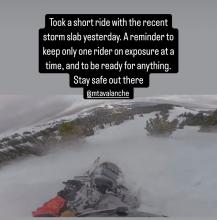
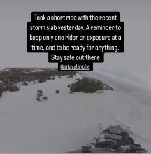
SS-AMu-R2-D2
Coordinates: 45.1719, -111.3800
Caught: 0 ; Buried: 0
From IG Message/ Stories: “Took a short ride with the recent storm slab yesterday. A good reminder to keep only one rider exposed at a time, and to be ready for anything. Stay safe out there.”
More Avalanche Details
HS-AMr-R3-D2-O
Elevation: 8,800
Aspect: NE
Coordinates: 45.0773, -110.0210
Caught: 0 ; Buried: 0
A rider triggered a slide on Saturday (2/22) on a bench below the east face of Mt. Abundance... Trigger point was from the top while driving by. 2' deep, 250' wide??
More Avalanche Details
SS-AMu-R3-D2-O
Elevation: 9,000
Coordinates: 44.9096, -111.1940
Caught: 1 ; Buried: 1
Snowmobile triggered avalanches that resulted in a partial burial with no injuries on Friday, Feb 21 and a second slide on Saturday, Feb 22 with no one caught.
More Avalanche Details

HS-N-R2-D1.5-I
Elevation: 9,000
Aspect: NE
Coordinates: 45.9151, -110.9810
Caught: 0 ; Buried: 0
From obs: "Saw a recent cornice triggered wind slab off of Hardscrabble Peak, crown looked fairly fresh. There was a second crown line below the rock band. Conditions were very windy, with snow still being transported. Most snow surfaces were wind affected, but saw no cracking or collapsing."
More Avalanche Details
ACc-R2-D2-O
Aspect: N
Coordinates: 45.6553, -110.5580
Caught: 0 ; Buried: 0
From IG story. "Cornice triggered persistent on a protected north face up Suce Creek. 3-4 ft deep. Absarokas are not like the Bridgers, Gallatins, etc. A few weeks ago we found the entire snowpack to be faceted top to bottom in Mill Creek...."
More Avalanche Details
HS-AMr-R2-D2-O
Elevation: 9,000
Aspect: SW
Coordinates: 44.9330, -111.3240
Caught: 0 ; Buried: 0
From IG message: "We remotely triggered this hillside in Taylor's fork yesterday [2/21] from the Ridgeline above it. We were looking for a safe spot to drop down when it released below us. Circled around for some pictures. The snow was pretty shallow, only 2-3 feet deep, and slid to the ground. South facing slope"
More Avalanche Details
WL-N-R1-D1
Elevation: 8,000
Aspect: S
Coordinates: 45.8822, -110.9520
Caught: 0 ; Buried: 0
"...We saw a handful of small point releases on steep south slopes, likely from Friday, but no other recent avalanche activity. By mid-day/early afternoon, the snow lower down in the woods was getting pretty heavy and wet and anywhere with the slightest bit of sun exposure was developing a crust..."
More Avalanche Details
Coordinates: 45.3690, -111.1750
Caught: 0 ; Buried: 0
From youtube comment: "Sooooo many pin wheels coming down in the Gallatin canyon today on my way home from work. I was driving and couldn't get a full look, but half way through the canyon, it looked like a whole, relatively small, slope slid, maybe propagated 50-75ft on the west facing side of the road."
More Avalanche Details
SS-AMu-R2-D2
Aspect: NE
Coordinates: 44.9041, -111.1850
Caught: 1 ; Buried: 1
From email: "One of my crew was partially buried in an avalanche today(head about 1’ down, leg and arm still above snow) at approximately 13:10 hrs. Slope was greater than 35 degrees, crown approximately 85 yards wide, over 3’ at its thickest point. I believe it was a NE exposure with wind loading at the top. I had a bad feeling about this slope and mentioned it to my crew and avoided riding on it until one rider ran out of gas and I had to help him. Upon completion of task, I rode back to a spot that wasn’t as safe a vantage point as what I had previously stayed at, but the intention was we were all on our way out. So I parked and within 30 seconds, I hear my friend yelling behind me. I turn and immediately think “oh he’s about to hit us”. So, I attempted to start up my sled, to no avail While watching behind me. Suddenly, a massive “snow cloud” appeared about 30 yards above him and it took about 2-4 seconds to register that it was an avalanche and not another rider careening out of control at us. By that time, it was too late to do anything. The avalanche had reached the back of my friend and my sled, pushing us forward about 6 feet at 3-4mph. After it stopped, I assessed 3 of four of our team was accounted for, and one (the one who yelled at us) was not. He was partially buried by the front of the avalanche much like our sleds were. Fortunately, within 5 seconds, I saw an arm and a leg sticking out of the snow and we had his airway and head cleared within about 20 seconds. He was located approximately 10 yards from us. "
More Avalanche Details
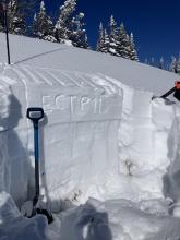
Coordinates: 45.0607, -111.2720
Caught: 0 ; Buried: 0
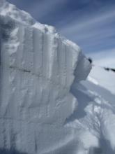
While traversing to our pit site in Sunlight Basin, we triggered a whumpfing collapse and a shooting crack up to 100' long across an adjacent slope. This snowpit on a SE aspect was made up of a dense slab of recent snow, sitting on top of many different layers of junky, faceted grains. Propagation was easy to find (ECTP 11, HS: 112).
More Avalanche Details

WL-N-R1-D1
Aspect: S
Coordinates: 45.1170, -109.8930
Caught: 0 ; Buried: 0
A wet loose avalanche occurred sometime today between 11-2 pm on S facing terrain nearby
More Avalanche Details
SS-N-R2-D2
Coordinates: 45.0607, -111.2720
Caught: 0 ; Buried: 0
We saw up to five recent avalanches from the last few days. 1-2 looked to have failed on PWLs, and the rest were wind slabs. Cornice collapses triggered at least two of these avalanches.
1. Cornice triggered wind slab in Sunlight Basin
2. Cornice triggered avalanche in Sage Creek
3. Likely PWL avalanche W of Kirkwood Ridge, lower in Cabin Creek
4. Older wind slab SW flank, Sage Peak
5. Likely PWL avalanche backside of Sage Peak
More Avalanche Details
SS-N-R1-D1
Aspect: SW
Coordinates: 45.1170, -109.8930
Caught: 0 ; Buried: 0
Today we observed a couple day old wind slabs in steep SW facing terrain on Mt Zimmer. Also, a wet loose occurred sometime today between 11-2 pm on S facing terrain nearby
More Avalanche Details
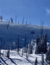
L-NC
Coordinates: 45.7943, -110.9360
Caught: 0 ; Buried: 0
Note from BB ski patrol - skiers triggered a medium sized cornice fall that triggered a dry loose (sluff) avalanche that created large powder cloud.
More Avalanche Details
SS-N
Elevation: 9,000
Aspect: S
Coordinates: 45.9233, -110.9800
Caught: 0 ; Buried: 0
Toured out to Frazier Basin and turned around seeing widespread avalanches and active wind loading. Despite our pits on the Throne the day before showing no weak layers, the amount of wind loading and potential for slabs over density changes gave us pause. Good skiing and sledding down low.
More Avalanche Details
SS-AMr-R3-D2-O
Elevation: 8,600
Aspect: SE
Coordinates: 44.7145, -111.3180
Caught: 0 ; Buried: 0
As we approached our second pit site on the lip of Moto Hill (southeast aspect at 8600'), I stopped and looked back in time to see avalanche debris slamming into the trees on a connected slope below. We remotely triggered the avalanche from 150 feet away. It broke 200' wide and 1-3 feet deep. It ran an estimated 200' vertical feet (based on a slope map. We couldn't safely access the toe of the debris). The avalanche failed on a layer of Fist hard facets. This is interesting because it is these mid-elevation slopes in the LH area that seemed really weak on previous visits to the area. The slope may have some wind-loading, but it was minimal and not the cause of this avalanche.
We dug a pit on an east aspect around the corner and down from Airplane Bowl (before the avalanche) and found a similar snowpack setup. 150 cm of total snow and half was composed of weak facets. ECTP22 and P24 on the mid-pack January layer of Fist hard facets and surface hoar.
Take Homes:
- Lionhead seems to be the epicenter of persistent slab instability. It is the weakest I have seen. Southern Madison and Southern Gallatin seem to be similar and I would group them together when describing conditions.
- Mid-elevation slopes are thin and weak and can clearly avalanche. This is problematic because many folks play in lower elevation terrain when conditions are dangerous... While small compared to the upper bowl, the avalanche we triggered would have been deadly. It was deep and it would have strained its victim through trees.
- We heard about a similar remote-triggered avalanche in Black Canyon today. This has me nervous that I missed something in the Centennials. While we didn't see anything too concerning there yesterday outside of wind-loaded slope, I am not happy about two remotely triggered slides less than 20 mile away.
More Avalanche Details

SS-AMr-R3-D2-O
Elevation: 8,000
Coordinates: 44.4780, -111.1350
Caught: 0 ; Buried: 0
From SnoWest Forums FB Page:
“Just getting word of a LARGE Remote Rider Triggered Slab Avalanche down inside of Black Canyon itself just off the Black Canyon Loop Trail in Island Park.
A 3-4ft thick slab broke loose and filled the bottom of the canyon with 12-15 FEET of debris, completely blocking off the canyon itself. Rider was NOT caught in it!! Had the rider been caught, there would have been ZERO chance of rescue under such a deep slide!”
More Avalanche Details
SS-NC-R1-D1.5
Aspect: E
Coordinates: 45.7943, -110.9360
Caught: 0 ; Buried: 0
Cornice broke in between north and south saddle peaks. The initial propagation width was hard to distinguish. Maybe 50 feet. About 18 inches deep at height of crown.
Skied down Rocky Rib and then into south east facing trees that follow the path. At the Argentina/ Shushmans traverse elevation there was a visible 2 foot wall and the slide had continued over the roll below.
More Avalanche Details
SS-NCc-R1-D1
Elevation: 10,000
Aspect: NE
Coordinates: 45.4444, -111.0040
Caught: 0 ; Buried: 0
2/17 Immediately noticed signs of wind loading and wind slabs on NE-E aspects once in the basin. New cornices have formed in the last couple days along the North ridge to the summit. Cornice collapse on the summit triggered a small wind slab on an isolated slope.
More Avalanche Details

SS-N-R1-D1.5
Elevation: 8,000
Aspect: E
Coordinates: 45.8301, -110.9340
Caught: 0 ; Buried: 0
3 small storm slabs observed on steep terrain of Bridger Ridge (E aspect observed from wolverine woods) Attached is a photo of the deepest likely ~12in crown
No observed wind slab development below 8100ft. No propagating test results in pits dug Lower ramp, and wolverine woods.
More Avalanche Details
SS-ASc-R1-D1-S
Aspect: E
Coordinates: 45.3374, -111.3810
Caught: 0 ; Buried: 0
Cohesive wind slabs roughly 1 foot deep were triggered between middle peak and the going home chute on the northeast aspect. Upon skiers weight shooting cracks traveled roughly 100 feet to trigger a small avalanche. The size was small as only the top 50 feet of the slope slid but the snow from the avalanche carried down the entire face.
More Avalanche Details
R2-D2-S
Elevation: 8,500
Aspect: E
Coordinates: 45.8822, -110.9520
Caught: 0 ; Buried: 0
From IG: 3 separate natural slides viewed south of the throne today. All east facing. This was the biggest.
If this is R3 others were more R2
More Avalanche Details
SS-ASc-S
Coordinates: 45.8288, -110.9310
Caught: 0 ; Buried: 0
While skiing a SE-facing slope, we found cracking and some cohesion in the new snow. This was mostly on very steep and rocky terrain features. The most notable of these was about 20’ wide, the bottom part of the new slab only moved about 6” before stopping, while the upper foot of the slab ran the full face.
More Avalanche Details
SS-N-R2-D2-S
Coordinates: 45.8288, -110.9310
Caught: 0 ; Buried: 0
Most steep chutes we skinned near had a debris pile at the bottom (running full path).
More Avalanche Details
SS-ASc
Coordinates: 44.9855, -109.9410
Caught: 0 ; Buried: 0
A member of our party intentionally triggered a 30-40cm storm slab on a small convexity in treed terrain in Wyoming Creek.
More Avalanche Details
SS-N-R2-D2-S
Elevation: 9,200
Aspect: E
Coordinates: 44.9855, -109.9410
Caught: 0 ; Buried: 0
Observed a D2 natural (wind/storm slab? Hard to say from my vantage) on E aspect at ~9200ft.
More Avalanche Details

SS-R3-D2-O
Elevation: 8,700
Aspect: E
Coordinates: 45.1719, -111.3800
Caught: 0 ; Buried: 0
In nearly 45 miles of riding, we noted two avalanches. Both breaking on persistent weak layers a few feet down in the snowpack. The first was a small north-facing pocket in the First Yellow Mule (R1-D1) that was snowmobile triggered. It looked to be around a week old. The second was a larger avalanche (R3-D2), east-facing, deep in Muddy Creek. This was drifted in and likely broke around 2.5 weeks ago during the last significant storm cycle.
More Avalanche Details
SS-AS-D1
Elevation: 9,000
Aspect: E
Coordinates: 44.9855, -109.9410
Caught: 0 ; Buried: 0
Today I triggered a D1 soft slab in Republic Creek, E facing slope, 9000 ft. It was 3 inches deep, 30 feet wide and ran 20 feet. No one was caught
More Avalanche Details
SS-ASc-R1-D1-I
Elevation: 8,129
Aspect: NW
Coordinates: 45.4658, -110.9510
Caught: 0 ; Buried: 0
SS-ASc-R1-D.5-I
310 Degrees NW
8129ft
More Avalanche Details
SS-ASu-R1-D1
Coordinates: 45.4036, -111.0310
Caught: 0 ; Buried: 0
More Avalanche Details
AM
Coordinates: 44.7254, -111.3320
Caught: 0 ; Buried: 0
Avalanche in Lionhead. Broke on wind slab then triggered persistent slab underneath.
More Avalanche Details
SS-AMu-R2-D2-S
Coordinates: 45.1719, -111.3800
Caught: 0 ; Buried: 0
Buck ridge, snowmobile triggered avalanche. Propagated storm slab.
More Avalanche Details
L-N-R1-D1-S
Coordinates: 45.0344, -109.9840
Caught: 0 ; Buried: 0
Today we saw a D1 dry loose in the Ghost Couloir. It ran 200 feet. We also felt one small collapse on a south facing slope. No other avalanches observed.
More Avalanche Details
SS-N-R2-D2-I
Elevation: 9,800
Aspect: E
Coordinates: 44.9952, -109.9080
Caught: 0 ; Buried: 0
In Hayden Creek, we saw many D1-D1.5 wind slab avalanches seen on leeward slopes- east and northeast slopes at and above treeline. We observed cracking in wind loaded areas above treeline. Dug a pit and did a quick ECT on E facing terrain at 9750ft. HS 190-210. ECTN6 30cm deep. No dirt layer.
More Avalanche Details

SS-AS-R1-D1
Coordinates: 45.6553, -110.5580
Caught: 0 ; Buried: 0
Toured up around Blackmore and s cottonwood. Found an extremely reactive windslab in the afternoon. It was thin, but easily triggered and would propagate about the width of each terrain feature (20-50ft). Each slab ran the length of the slope (150-200 ft).
More Avalanche Details
HS-N-R1-D1-S
Elevation: 8,130
Aspect: E
Coordinates: 45.0607, -111.2720
Caught: 0 ; Buried: 0
We rode into the Taylor Fork, down into the bottom of Sunlight Basin, across Carrot Basin and to the Wilderness Boundary.... Additionally, we saw one wind slab avalanche (R1, D1) in Sunlight Basin. This slide was fresh from this morning or yesterday.
More Avalanche Details
Caught: 0 ; Buried: 0
Climbing at the Unnamed Wall in the vicinity of The Fat One, there are some 3"–8" wind slabs formed. At least three small pockets had released from 2" to 5" deep. Lots of spindrift and heavy winds filled in parts of our trail in a few minutes.
More Avalanche Details
AMu-R1-D1
Coordinates: 44.7145, -111.3180
Caught: 0 ; Buried: 0
From FB message: "Small slide in lower elevation back by lionshead"
More Avalanche Details
SS-N-R1-D1
Elevation: 9,150
Aspect: E
Coordinates: 44.9731, -111.3100
Caught: 0 ; Buried: 0
We saw one wind slab avalanche (R1, D1) in Sunlight Basin. This slide was fresh from this morning or yesterday. 50 feet wide and 6 inches deep.
More Avalanche Details

SS-N-R1-D1
Elevation: 7,500
Aspect: W
Coordinates: 45.4415, -110.9540
Caught: 0 ; Buried: 0
Climbed in the Mummy II area in Hyalite today. West facing ~7,500'. Lots of spindrift coming down onto the climbs in the area and we noticed lots of snow blowing around up high. No snow fell while we were there but our trail in was almost fully filled in and covered with a few inches to a couple feet of wind slab on the way out. Saw a small natural slide that started at the bottom of Cyptorchid. Crown was 10' wide and 8-18" deep, it ran 150' down a very shallow slope and covered the climbers trail.
More Avalanche Details
SS-ASu-R1-D1
Elevation: 9,850
Aspect: E
Coordinates: 45.4596, -111.0020
Caught: 0 ; Buried: 0
Triggered a small wind slab avalanche on the east face of mt Blackmore today at 9850 ft elevation. Around 5 inches thick, ~ 20 ft wide, and ran for 100 ft. No skiers were caught but the slab was very reactive. We were assessing the snow as we climbed but skied a slightly more eastern aspect than we were planning and it was more reactive than expected. Strong winds gusting all day, no active transport observed but obvious that the wind slabs have not settled.
More Avalanche Details
SS-R1-D1
Coordinates: 45.4234, -111.1250
Caught: 0 ; Buried: 0
Sledded up storm castle. Spent the majority of the day skinning and skiing NE to NW aspects. Found debris from multiple R1-D1 wind slabs from earlier this week. Found widespread but inconsistent wind slabs (2"- 6" thick) at elevations 6700' to 8400'. Throughout the day cracking and collapsing was noticed multiple times on areas of stiffer snow. Snow quality changed dramatically from powder turns to thick wind crust with no visual surface difference.
More Avalanche Details
SS-NC-R3-D2
Elevation: 10,400
Aspect: E
Coordinates: 45.0303, -109.9980
Caught: 0 ; Buried: 0
Noticed a large cornice triggered avalanche on Mineral Mtn today. Likely broke on 2/12 or early am 2/13. E aspect ran almost to the valley floor. Active Loading today with Strong Gusts from N-S. There were some other small cornice avalanches to the north of this slide that did not trigger larger avalanches.
More Avalanche Details
SS-N-R2-D1.5
Elevation: 9,200
Aspect: N
Coordinates: 45.9233, -110.9800
Caught: 0 ; Buried: 0
We saw a natural avalanche (R2, D1.5) that released on a steep headwall just to the south (I believe I’ve heard this referred to as October Bowl).
Wind has affected most of the snow above forested terrain in some fashion. While most soft snow has already been redistributed, some transport continued.
More Avalanche Details

SS-AM-R2-D2-O
Elevation: 9,200
Coordinates: 45.0607, -111.2720
Caught: 0 ; Buried: 0
We rode into the Taylor Fork, down into the bottom of Sunlight Basin, across Carrot Basin and to the Wilderness Boundary. We saw four persistent slab avalanches that likely broke last weekend or at the beginning of the week. All appeared to be snowmobiler-triggered R1-2, D1.5-2 avalanches at broke of the January layer of near-surface facets and surface hoar. Additionally, we saw one wind slab avalanche (R1, D1) in Sunlight Basin. This slide was fresh from this morning or yesterday.
We dug a crown profile for the persistent slab avalanche in Sunlight (attached). ECTN24 on the SH layer buried 50 cm (20") deep.
More Avalanche Details
SS-N-R1-D1.5
Elevation: 10,100
Aspect: SE
Coordinates: 44.9855, -109.9410
Caught: 0 ; Buried: 0
Saw what looked to be a small wind slab or cornice fall on South Siren in Republic Creek. SE facing, 10100 ft.
More Avalanche Details
SS-R1-D1
Coordinates: 45.0999, -109.8840
Caught: 0 ; Buried: 0
Went skiing north of Cooke City today near Zimmer Creek. I saw a few wind slabs. Some appeared to be skier triggered, some were natural. No other avalanches seen. Moderate to strong wind from the west all day. I saw shooting cracks in obviously windloaded areas.
More Avalanche Details
Coordinates: 44.8502, -111.7670
Caught: 0 ; Buried: 0
From FB message: "Two snowmobiler triggered avalanches in Gravelly Range. Riders did not have beacons or rescue equipment. Riders made it out safe luckily."
More Avalanche Details
SS-AM-R1-D1
Aspect: S
Coordinates: 44.7292, -111.3230
Caught: 0 ; Buried: 0
We saw this today after it happened. Looked like a snowmobile triggered it. I believe it is mostly south facing. Thanks.
More Avalanche Details
HS-N-R1-D1.5-S
Elevation: 9,900
Aspect: E
Coordinates: 45.0530, -110.0100
Caught: 0 ; Buried: 0
On Feb 9 We saw a fresh natural wind slab near Wolverine, R1-D1.5
More Avalanche Details
SS-AS-R1-D2-S
Elevation: 9,500
Aspect: SE
Coordinates: 45.0733, -109.9480
Caught: 0 ; Buried: 0
We watched two snowboarders trigger separate wind slabs, while riding one at a time in avalanche terrain, on the south side of Scotch Bonnet (photos attached). They rode away safely. These looked 12" deep and 20' wide, and entrained snow to run a good distance, R1-D2.
More Avalanche Details

SS-N-R2-D1.5
Elevation: 8,400
Aspect: E
Coordinates: 45.8301, -110.9340
Caught: 0 ; Buried: 0
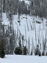
Toured the ramp today and observed an avalanche in hour glass. It was a soft slab that broke in some rocks near the top of the chute, it ran the entire length of the chute and the debris was fairly large (d1.5). The crown looked to be between 8” and 1.5 ft, and was about 30 ft wide.
More Avalanche Details
Elevation: 7,800
Aspect: NW
Coordinates: 45.5987, -111.0330
Caught: 0 ; Buried: 0
Toured into the north Gallatin today and skied on north facing terrain. Saw obvious loading in the new snow up high on the ridge lines, but no recent natural avalanches. We encountered several debris piles that were covered by new snow, probably from a few days ago and likely wind slabs based on the terrain. Skiing, we triggered 3 wind slabs (ss-d1-r1) on a north west facing slope at around 7800’, each ran the entirety of the face. Notably, one of the slabs propagated above the skier and about 20-25 ft to the right. Skiing a north east slope (slightly more sheltered), no signs of instability were observed. We didn’t observe a weak layer underneath the most recent new snow, but we did see a layer of dust and crust deeper in the pack.
More Avalanche Details
SS-AS-R1-D1
Elevation: 9,500
Aspect: SE
Coordinates: 45.0745, -109.9070
Caught: 0 ; Buried: 0
Saw this small soft slab above Round Lake today. SE facing, 9500 ft. Likely skier triggered, there were lots of ski tracks on that hill.
Poor visibility today but no other avalanches observed.
More Avalanche Details
SS-AFr-R2-D1-S
Elevation: 7,500
Aspect: N
Coordinates: 45.8822, -110.9520
Caught: 0 ; Buried: 0
We saw a couple storm slabs that broke in today's snow 4-6" deep, 10-30' wide, and we triggered one 3-4" deep wind slab, "remotely", from a few feet back on a small ridgeline. R2-D1. These slabs were very soft, F- to F hard.
More Avalanche Details
SS-AFu-R1-D1
Aspect: W
Coordinates: 45.4472, -110.9620
Caught: 0 ; Buried: 0
At the base of G2 I triggered a 3 inch x 100 foot soft slab. I was surprised how far it propagated. It looked like it failed on a density change under the morning's new snow. 40 feet up on the first large bench we triggered another slide, 6 inches deep, the entire width of the bench. It could have pushed a climber off if they were in the middle of it. It was snowing steady (1"/hr) and wind was minimal, but a few hours later we could see plumes higher up in the gullies.
It had such zip to the propagation that I'm thinking it might take a day for it to not be reactive. There was no way we wanted to get on anything open and steep.
More Avalanche Details
SS-N
Aspect: E
Coordinates: 45.8301, -110.9340
Caught: 0 ; Buried: 0
After skiing Bradley's Meadow, we skied north into Wolverine Bowl aiming to go up the backside of Texas Meadows. When we were in the large flat meadow to the north of Hourglass Chute we heard two avalanches come down from the ridge a few hundred yards north of Hourglass. Too low of vis to estimate size or see anything but the powder clouds come over the bottom cliffs.
More Avalanche Details
SS-N
Coordinates: 45.5777, -110.9550
Caught: 0 ; Buried: 0
Skied big Ellis this morning. The temperature inversion was still active but not as dramatic as yesterday. The snow in the warm zone, near the top, of the inversion was well bonded and clearly affected by warmer temps. It was snowing hard up there but coming down as graupel. In the cold zone of the inversion the new snow was extremely active. We were remote triggering every small slope we passed on the gully exit. We saw many naturals breaking on any large open slope in the gully. The snow on the cold side of the inversion was blower but not bonding well at all. Could be a very sketchy setup if you find your self skiing in avy terrain that stayed cold over the last few days.
More Avalanche Details
SS-ASr-R1-D1
Elevation: 7,200
Aspect: SE
Coordinates: 45.8627, -110.9360
Caught: 0 ; Buried: 0
New storm snow accumulating over the course of the morning became quite reactive once we descended out of the inversion. Significant change starting around 7,200', where the surface had remained cold. We didn't observe any signs of instability while skiing between ~8,200' and ~7,200'.
Photo is a of remote trigger, SE facing slope, ~100' crown, ~3" depth. Lots of shooting cracks and smaller remote triggers while touring out the FS roads.
More Avalanche Details
SS-ASu-R1-D1.5
Aspect: NE
Coordinates: 45.7943, -110.9360
Caught: 0 ; Buried: 0
Three skiers descending the northside of Skyline Ridge on Saddle Peak triggered a wind slab avalanche that ran 400 vertical feet. No one was caught.
More Avalanche Details
SS
Coordinates: 44.7145, -111.3180
Caught: 0 ; Buried: 0
Plenty of wind slabs ranging in size on Lionhead ridge and on surrounding slopes. Noticed a few natural slides on the way in, a few more on the way out that were rider triggered. Snow was quite wet by this afternoon @8500’.
More Avalanche Details
SS-N-R2-D2
Coordinates: 45.0202, -109.9380
Caught: 0 ; Buried: 0
Avalanches on north Fisher Mountain and north Crown Butte likely occurred sometime between 2/2-2/3. The avalanche on east Henderson occurred between 11:30-12:30 on 2/4.
More Avalanche Details

SS-N-D1
Elevation: 7,500
Aspect: E
Coordinates: 45.9043, -110.9580
Caught: 0 ; Buried: 0
Toured up around fairy lake today, winds were ripping all day. Saw several d1 soft slabs in upper elevation terrain, many of them running quite far. We opted ski a lower elevation zone and were surprised to find a soft slab (d1/r1) that ran on an east facing slope at about 7500’ and about 500-600 ft below the ridge line on a slope just over 30 degrees.
More Avalanche Details
SS-N-R1-D1
Coordinates: 45.1719, -111.3800
Caught: 0 ; Buried: 0
On the headwall of the Second Yellow Mule, we saw two recent wind slab avalanches. These were small (R1 D1), immediately below the ridge, and likely broke late last night or this morning.
More Avalanche Details
SS-N-R2-D1.5-S
Elevation: 9,600
Aspect: E
Coordinates: 45.4444, -111.0040
Caught: 0 ; Buried: 0
The wind had hammered snow surfaces at all elevations above tree line on Mount Blackmore. There was evidence of several R1-2/ D1-2 wind slab avalanches that likely ran this weekend on the east face of Blackmore.
More Avalanche Details