Good morning. This is Dave Zinn with the Gallatin National Forest Avalanche Forecast on Tuesday, January 17th at 7:15 a.m. This information is sponsored by Spark R&D and Uphill Pursuits. This forecast does not apply to operating ski areas.
One to two inches of snow fell across the advisory area yesterday morning before the clouds began to break. This morning, temperatures are in the single digits to teens F with 5-10 mph wind from the west to northwest. Today, temperatures will be in the 20s F with 5-10 mph wind from the west to the north and there will be no new snow.
A heightened avalanche danger exists in the mountains near Big Sky through the Lionhead area and Cooke City. In the last four days, 7-10” of snow around West Yellowstone and Cooke City and 5” near Big Sky incrementally loaded a layer of weak surface hoar crystals buried 1-2’ deep. This weekend, we know of two skier-triggered avalanches near Hebgen Lake that failed on this layer (observation, photo and details). Yesterday, Alex saw a rider-triggered avalanche on Henderson Mountain that occurred in the last couple of days (photo and details). During field days, we have seen this layer on many slopes from Big Sky through the southern portion of the advisory area (Beehive Basin, Buck Ridge, Lionhead video, Cooke City video, Taylor Fork video). While its distribution can be spotty, assume it is on all slopes and can produce avalanches if we ride or ski across the wrong spot.
Avalanches within the new and wind-drifted snow like a natural avalanche observed in Cooke City this weekend (details) and slides breaking on weak layers buried deeper in the snowpack are also possible.
Dig, test and maintain a conservative mindset when selecting terrain due to persistent weak layers demonstrating a potential to fail and avalanche. Dangerous, human-triggered avalanches are possible today, and the danger is rated MODERATE.
In the mountains around Bozeman, 3-6” of snow has fallen since the start of the weekend. Yesterday, skiers near Alex Lowe Peak noted small loose snow avalanches and another near Lick Creek was able to trigger a very small avalanche on a steep rollover in a 4” deep wind drift (photo and details, observation). Similar avalanches are possible today and will increase in size and likelihood if the wind picks up. As Alex noted in his video from Mount Blackmore, without the loading from a more significant snowfall event, avalanches breaking deeper in the snowpack are less likely. However, the structure is poor, with weak layers near the ground and in the middle of the snowpack. Two groups of skiers over the MLK weekend noted this structure in the Bridger Range (observation 1). One of the two groups chose to retreat to conservative terrain after getting unstable test results in Frazier Basin (observation 2).
Mitigate the avalanche danger by testing weak layers deeper in the snowpack before considering skiing or riding on steeper slopes and selecting terrain that minimizes the consequences of triggering a slide.
The danger is rated MODERATE.
Please share avalanche, snowpack or weather observations via our website, email (mtavalanche@gmail.com), phone (406-587-6984), or Instagram (#gnfacobs).
A heightened avalanche danger exists in the mountains in Island Park. In the last four days, 12” of snow total has incrementally loaded a layer of weak surface hoar crystals buried 1-2’ deep. Slides within the new and wind-drifted snow and avalanches breaking on weak layers buried deeper in the snowpack are possible. Dig, test and maintain a conservative mindset when selecting terrain due to persistent weak layers demonstrating a potential to fail and avalanche.
Doug and I will be riding in the Centennial Range today. Follow the GNFAC’s social media channel’s this evening for a video about what we find.
Upcoming Avalanche Education and Events
Our education calendar is full of awareness lectures and field courses. Check it out: Events and Education Calendar.
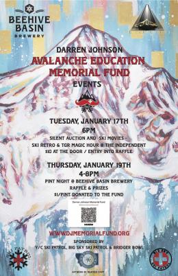
TONIGHT, Tuesday, January 17th, 6 p.m., Silent auction and ski movies to support the Darren Johnson Memorial Avalanche Education Memorial Fund @ The Independent in Big Sky, $10
Thursday, January 19th, 4-8 p.m., Pint Night to support the Darren Johnson Memorial Avalanche Education Memorial Fund @ Beehive Basin Brewery
Every Saturday, 10 a.m. - 2:00 p.m. Avalanche Rescue Training, drop in for any amount of time. Round Lake Warming Hut, Cooke City. Free.
Loss in the Outdoors, is a support group for those who have been affected by grief and loss related to outdoor pursuits. Check out the link for more information.
KING AND QUEEN OF THE RIDGE, FEBRUARY 4TH
Do you like to hike? Do you like to ski? Then the King & Queen of the Ridge is for you. Hike, ski and raise money for the Friends of the Avalanche Center in their 2nd biggest fundraiser of the year. Join the effort to promote and support avalanche safety and awareness! Fundraising prizes for the top 5 individuals who raise over $500. No racing is necessary to compete for the fundraising prizes. Info is HERE. Race participants for the February 4th event must register separately with Bridger Bowl HERE.
There are two events happening next week to help spread awareness about the Darren Johnson Avalanche Education Fund and generate donations for the next recipients to attend National Avalanche School in October 2024: a movie night at the Independent Theatre on Tuesday, January 17 and a raffle and pint night at Beehive Basin Brewery on Thursday, January 19 (poster).


