Good morning. This is Dave Zinn with the Gallatin National Forest Avalanche Forecast on Tuesday, February 28th at 7:15 a.m. This information is sponsored by the Yellowstone Club Community Foundation and Montana State Parks. This forecast does not apply to operating ski areas.
This morning there is 2-4” of new snow near West Yellowstone and Cooke City and an inch near Bozeman and Big Sky. Temperatures are in the single digits to teens F and 10-25 mph winds from the south to west. Today, snow will continue to favor the mountains around West Yellowstone and Cooke City with 3-6” by tomorrow morning. The mountains around Bozeman and Big Sky will get 1-2”. Temperatures will be in the teens to 20s F with 15-25 mph wind from the southwest to west.
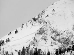
Excepting last Thursday, the mountains around West Yellowstone and Cooke City have received measurable snowfall every day for over a week, with 9-12” in the last two days and moderate to strong winds for the last four. A lot of new snow and strong winds will likely result in avalanches, especially on wind-loaded slopes where recent drifts could break from a few inches to several feet deep.
This has undoubtedly been the case in Cooke City, with many large natural avalanches and four people caught and partially buried since Saturday (Town Hill - 2 partially buried, Mt. Abundance - partial burial, Round Lake - partial burial). Browse through the Avalanche Activity Log on our website to see a complete list of recent activity. Take note of the great video a group of riders captured of a natural avalanche occurring near Pilot Creek on Friday (additional details). Yesterday, Alex and I rode north of Cooke City and described our concerns highlighting wind-loaded slopes (video).
We have not received an equivalent number of reports from the Lionhead area, but we know that recent snow and wind conditions have been similar, a rider was partially buried on Thursday (details) and a second group submitted a photo of a recent avalanche on a wind-loaded slope.
Avoid steep, wind-loaded slopes where triggering an avalanche is likely. Evaluate the snowpack for instabilities within or underneath recent snow before considering riding or skiing non-wind-loaded slopes. The avalanche danger is CONSIDERABLE on wind-loaded slopes and MODERATE on other slopes.

In the Gallatin, Madison and Bridger Ranges, 2-11” of snow since Saturday favored the areas further south. Slides breaking a few inches to 2 feet deep within drifts of the most recent snow are the most likely scenario today. Yesterday, the USFS snow rangers reported a small avalanche on a wind-loaded slope at Buck Ridge (photo and details). On Saturday, skiers in the Southern Gallatin Range intentionally triggered a small avalanche on a wind-loaded slope below a cornice (video). Last Friday, a rider triggered a small avalanche at Buck Ridge (photo and details), a large cornice collapsed in Bear Basin (photo and details), and large natural avalanches occurred on Mount Bole, Mount Blackmore and Fan Mountain. While less likely, larger avalanches similar to those in Hyalite and near Big Sky that break under the 2-4’ of snow from the last week are possible.
Identify and rule out wind-loaded slopes by noting, for example, active drifting or areas below or next to cornices. On non-wind-loaded slopes, test for instability with a quick snowpit before considering riding or skiing steeper terrain. Today, human-triggered avalanches are possible, and the danger is MODERATE.
Please share avalanche, snowpack or weather observations via our website, email (mtavalanche@gmail.com), phone (406-587-6984), or Instagram (#gnfacobs).

The Centennial Range received 10-14” of snow in the last 48 hours. Moderate to strong winds are transporting this snow into drifts on wind-loaded slopes where human-triggered avalanches are likely and natural avalanches are possible. Avoid steep, wind-loaded slopes. Evaluate the snowpack for instabilities within or underneath recent snow before considering travel on non-wind-loaded slopes.
Upcoming Avalanche Education and Events
Our education calendar is full of awareness lectures and field courses. Check it out: Events and Education Calendar.
March 3, 9 a.m.-3 p.m., Bozeman Splitfest - Companion Rescue Clinic. Classroom session followed by a field session. More information and registration HERE.
March 3-5, Bozeman Splitfest. More info and register here.
March 3 & 4, Companion Rescue Clinic. Online classroom session Friday evening followed by a field session from 10 a.m.-2 p.m. Saturday. More information and registration HERE.
March 9, 6 p.m.-7 p.m., 1-Hour Awareness - Spring conditions. FREE at REI Bozeman.
March 10 & 11, SheJumps - Women’s Companion Rescue Clinic. Online classroom session Friday evening followed by a field session from 10 a.m.-2 p.m. Saturday. More information and registration HERE.
Every Saturday, 10 a.m. - 2:00 p.m. Avalanche Rescue Training, drop in for any amount of time. Round Lake Warming Hut, Cooke City. Free.
Loss in the Outdoors, is a support group for those who have been affected by grief and loss related to outdoor pursuits. Check out the link for more information.
Tragically, last Thursday in Wyoming a snowmobiler was buried and killed in an avalanche. Over the weekend in Colorado, two skiers were buried and killed, and one snowmobiler was buried and is still missing. Current details for these accidents are available HERE.