Good morning. This is Doug Chabot with the Gallatin National Forest Avalanche Forecast on Wednesday, March 15th at 7:15 a.m. This information is sponsored by Blitz Motorsports and Yamaha and Spark R&D. This forecast does not apply to operating ski areas.
AVALANCHE WARNING
The Gallatin National Forest Avalanche Center is issuing a backcountry avalanche warning for the Southern Gallatin and Southern Madison Ranges, the Lionhead area near West Yellowstone, the Centennial Mountains outside Island Park, and the mountains around Cooke City. A powerful storm has already dropped over a foot of dense snow with much more falling today. Very strong winds and heavy snowfall are creating very dangerous avalanche conditions. The danger is rated HIGH on all slopes. Human-triggered and natural avalanches are likely. Backcountry travelers should stay off of steep slopes and stay away from the bottom of steep slopes. Avalanches can be triggered from flat terrain.
This warning will expire or be updated by 6:00 a.m. on Thursday, March 16, 2023.
In the last 24 hours over a foot of new snow has fallen in Taylor Fork, around West Yellowstone and Cooke City. Around Big Sky, Hyalite and the Bridger Range, a trace to 2” fell. Southwest wind is averaging 25-30 mph with gusts of 64 mph. In the Bridger Range it is 10-30 mph from the west-southwest. Temperatures are in the mid 20s F. Snowfall will be strongest this morning and taper off this afternoon. A couple inches will fall in the Bridger Range and 4-6” is expected everywhere else. Wind will remain strong and switch to the northwest. Skies clear tonight.
Avalanche Warning
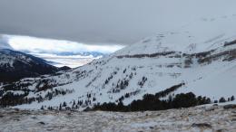
It is still snowing and blowing and the backcountry is dangerous today. At 6 a.m., more than a foot of dense snow has fallen (.9-1.5” snow water equivalent) in Taylor Fork, Lionhead, and Cooke City, and winds are exceeding 60 mph from the southwest. In the last 48 hours 1.5 to 2+ feet of snow has fallen. We were seeing large, deep avalanches leading up to this storm and I have no doubt that more slopes will avalanche today. Today is a day to be extremely cautious. Staying off steep slopes is obvious, yet staying clear of runout zones is less so, especially with poor visibility. Flat terrain under a steep slope (runout zone) is dangerous because not only can a slide be triggered from here, but burials are not uncommon. Many people have been buried and killed while traveling in seemingly safe runout zones.
The avalanche danger is rated HIGH on all slopes. Avalanches are likely.

Winds are very strong with gusts over 60 mph. It is blowing from the southwest, but swirling at all elevations making it difficult to tell precisely where the loading is. Ian and I were on Buck Ridge and rode towards Cedar Mtn yesterday (video), and Dave was in Beehive and Bear Basin the day before (video). In both instances we were concerned with slabs of windblown snow breaking. It has not started snowing yet (7 a.m.), but if it does the danger will rise. Large avalanches are being triggered with little load throughout our forecast area. During and immediately after a snowstorm is the most likely time to trigger slides. For today, triggering slides is possible, especially on slopes with wind-drifts.
The avalanche danger is rated MODERATE on all slopes, but could rise to CONSIDERABLE if more than a few inches of snow falls this morning
The Bridger Range received a couple inches of ball-bearing, graupel snow yesterday morning while it rained at lower elevations. Wind is light compared to the rest of our advisory area. It is averaging 10 mph with gusts of 30 from the west to southwest and wind-loading will be minimal. A large avalanche in the Fairy Lake area on Sunday is evidence that the Bridger Range is not immune to deep and deadly slides (observation and photos). A couple inches of snow yesterday will keep us on our toes. Search for wind slabs, which may crack in front of you, be careful around cornices and don’t forget that large avalanches are not out of the question.
The avalanche danger is rated MODERATE on all slopes.
Upcoming Avalanche Education and Events
Our education calendar is full of awareness lectures and field courses. Check it out: Events and Education Calendar.
Saturday, 10 a.m. - 2:00 p.m. Avalanche Rescue Training, drop in for any amount of time. Round Lake Warming Hut, Cooke City. Free.
Sunday, March 26, Avalanche Alliance Sweepstakes! Proceeds help support avalanche centers. Use code LASTCHANCE to receive 40% more tickets. Winners will be chosen at the Jackson Hole Hill Climb.
Loss in the Outdoors is a support group for those affected by grief and loss related to outdoor pursuits. Check out the link for more information.
A list of all avalanche activity from our forecast area is available HERE.