Good morning. This is Ian Hoyer with the Gallatin National Forest Avalanche Forecast on Friday, April 7th at 7:00 a.m. This information is sponsored by Yellowstone Club Community Foundation and Montana State Parks. This forecast does not apply to operating ski areas.
There is no new snow. Winds are 10-15 mph out of the southwest and west with gusts of 25-30 mph. Temperatures are in the teens and low 20s F. Temperatures will rise into the 30s and 40s F this afternoon under mostly sunny skies. Moderate southwest winds will continue. Sunny skies and warm temperatures will continue through the weekend.

All Regions
Spring is finally here. Temperatures will be 5-10 degrees warmer than yesterday and sunny skies will pump a lot of heat into the snow surface. This will add to wet snow concerns and raises uncertainty for the dry snow issues we’ve been dealing with for months.
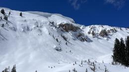
Wind slabs remain reactive and another weak layer was buried last weekend. Yesterday, a skier near Cooke City triggered a wind slab in the Rasta Chutes (observation) and natural slides broke 1-3 ft deep on wind loaded slopes near Cooke City and in the Bridgers (Cooke details, Saddle Peak details). In the Taylor Fork, I found a thin layer of weak facets ~18” below the snow surface and got unstable test results on it (ECTP13) (observation). A wetting snow surface may make it easier to trigger a slide on these layers today. Dig down to investigate the top couple feet of the snowpack for instability before riding steep slopes.
Triggering a big slide on deeper weak layers also remains possible. The last big slides broke last weekend (Lionhead, Cooke City and the Bridger Range). These layers are hard to test for so your options are really either to continue to avoid steep slopes entirely or to decide the probability is low enough that you’re willing to accept some chance of triggering a deep slide.
Wet loose avalanches in the upper snowpack will become possible as crusts break down and slopes heat up this afternoon. I don’t expect these slides to be big, but the April sun is very powerful and there is a good bit of soft snow at the surface that could be entrained, so there is substantial uncertainty. Be on alert for changing conditions because they could happen rapidly. Once there is more than a few inches of wet, sticky, surface snow, it’s definitely time to move off steep slopes.
With a wide range of concerns and human triggered avalanches possible, the avalanche danger is rated MODERATE today.
Our last daily forecast will be this Sunday, April 9. We will issue weather and avalanche observations every Monday and Friday through April. Please share avalanche, snowpack or weather observations via our website, email (mtavalanche@gmail.com), phone (406-587-6984), or Instagram (#gnfacobs).
Hyalite Canyon road is closed for motorized use until May 16.