Good morning. This is Ian Hoyer with the Gallatin National Forest Avalanche Forecast on Friday, January 26th at 7:00 a.m. Today’s forecast is sponsored by Cooke City Motorsports, Bridger Bowl and Bozeman Splitfest. This forecast does not apply to operating ski areas.
This is a trace to an inch of new snow. Winds are generally light at 5-10 mph out of the west and north, except in the Bridgers where they are 15-20 mph and gusting to 35 mph. Temperatures this morning are in teens and low 20s F. Today will be mostly sunny, with high temperatures in the 20s and 30s F. Winds will remain light. Snow showers tonight won’t amount to significant accumulations.
All Regions
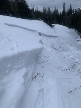
If you get on or near a steep slope today, you are likely to trigger a slide. We’ve let the avalanche warning in Island Park expire and the danger has dropped from high to considerable for the first time in a week in the other southern ranges, but don’t for a minute think this means conditions are safe. Skiers and riders across the advisory area continue to trigger avalanches from a distance and have widespread collapses and shooting cracks. The snowpack is unusually and remarkably weak - even the small amounts of snow that have fallen over the last week have kept it teetering on the edge. It’s been three weeks since the last day without reported avalanches or signs of instability (see the weather and avalanche log for the full list).
Some recent highlights include a slide reported yesterday that was likely skier triggered low on Saddle Peak (photos), riders in Tepee Basin having cracks shoot out 100 ft in front of them while sidehilling a low angled slope (details), and skiers remotely triggering avalanches multiple days in a row near Cooke City (details).
Slides are still being triggered from hundreds of feet away (Woody Creek remote trigger). This means you really need to be cautious even traveling near steep slopes. Simply avoid all slopes steeper than 30 degrees and also be very careful crossing beneath those slopes as well in case you trigger a slide above you.
Human triggered avalanches are likely and the avalanche danger is CONSIDERABLE.
If you get out please submit an observation. It does not need to be technical. Did you see any avalanches? How much snow is on the ground? Was the wind moving snow? Simple observations are incredibly valuable. You can also contact us by email (mtavalanche@gmail.com), phone (406-587-6984), or Instagram (#gnfacobs).
Upcoming Avalanche Education and Events
Our education calendar is full of awareness lectures and field courses. Check it out: Events and Education Calendar.
Every weekend in Cooke City: Friday at The Antlers at 7 p.m., Free Avalanche Awareness and Current Conditions talk, and Saturday from 10 a.m.-2 p.m. at Round Lake Warming Hut, Free Rescue Practice.
We offer Avalanche Fundamentals with Field Session courses targeted towards non-motorized travelers in January and one geared towards motorized users. Sign up early before they fill up.
King & Queen 2024, 3 February 2024. Form a team or sign up individually to hike laps on the Bridger Bowl ridge to fundraise for the Friends of the Avalanche Center.
Loss in the Outdoors is a support group for those affected by loss and grief related to outdoor pursuits. Check out the link for more information.
KING AND QUEEN OF THE RIDGE, FEBRUARY 3rd
Do you like to hike? Do you like to ski? Then the King & Queen of the Ridge is for you. Hike, ski and raise money for the Friends of the Avalanche Center in their 2nd biggest fundraiser of the year. Join the effort to promote and support avalanche safety and awareness! Fundraising prizes for the top 5 individuals who raise over $500. No racing is necessary to compete for the fundraising prizes. Info is HERE. Race participants for the February 4th event must register separately with Bridger Bowl HERE.
This year's snowpack is not to be trifled with.
Unusual weather leads to unusual avalanche conditions, and that is certainly the case this year. This year is unique in my 29 years of avalanche forecasting in southwest Montana. Large avalanches are being triggered from hundreds of feet away long after the most recent snowfall. Even a few inches of new snow is causing us to elevate the danger. This is not like other seasons, and it's making our entire forecasting team nervous. We are recalibrating our risk and notching back our travel plans due to a great deal of uncertainty about what it will take for things to become more stable.
Typically, the snowpack begins to adjust to new snow within a few days after a storm, avalanches and obvious signs of instability like whumpfing decrease, and we can start notching down the avalanche danger. This year is different. Our current snowpack is stabilizing at a rate that is agonizingly slow. The only real solution to our current snowpack situation is patience. With our current weak layers, every small storm is likely to raise the avalanche danger, and instability will lurk on many slopes long after the snow falls.
-Doug Chabot