Good morning. This is Ian Hoyer with the Gallatin National Forest Avalanche Forecast on Saturday, March 30th at 7:00 a.m. Today’s forecast is sponsored by Uphill Pursuits and Cooke City Super 8/Bearclaw Bob’s. This forecast does not apply to operating ski areas.
There is a trace to an inch of new snow across most of the advisory area, with 2” around Cooke City. Winds are generally 5-10 mph out of the southwest through east with 15-20 mph gusts, but are blowing 25-30 mph with gusts up to 100 mph in Island Park. Temperatures this morning are in the teens F and will rise into the high 20s and 30s F today. Winds will generally remain light. Expect a mix of sun and clouds again today, with snow showers not amounting to much accumulation. A couple inches of snow are possible overnight near Cooke City.

Strong winds are drifting the close to 2 ft of recent snow into big, deep, fresh drifts that will be easily triggered today. Avoid steep slopes with these fresh wind drifts to avoid the most likely setup for triggering a large avalanche. With such strong winds, drifts may have formed in unusual locations, so stay on high alert. If the snow suddenly feels hollow and stiff you’ve found one of these drifts. Shooting cracks are bullseye data that the drift is unstable.
In addition, if the sun wets the snow surface, wet loose avalanches will quickly become an issue and with so much soft new snow could be substantial enough to be problematic. We’re also not ready to forget about the possibility of triggering an even deeper slide on the early season weak layers.
The avalanche danger is CONSIDERABLE on wind-loaded slopes and MODERATE on all other slopes.

Winds are much lighter across the rest of the advisory area and there is less new snow. While there are a wide range of concerns today, we don’t expect widespread avalanching.
The number one concern to watch out for is unstable wind drifts. With winds shifting direction over the last couple days these drifts could be found on any aspect. Many drifts will have bonded well, but digging down to confirm they have is a good idea. Especially because, as Alex found yesterday in the Taylor Fork, in some places there is a newly buried weak layer under these drifts (observation).
The new snow will easily sluff if the sun and warm temperatures combine to make the surface wet for the first time. Be heads up if you feel the snow start to get sticky and begin to see rollerballs and pinwheels.
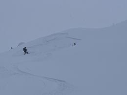
The final concern is avalanches breaking on the weak layers at the bottom of the snowpack. Yesterday, skiers on Mt. Blackmore saw a deep avalanche that broke within the last couple days (details and photos). It’s hard to tell from the photos exactly where in the snowpack it broke, but it doesn’t really matter, it’s a good reminder that there is still a possibility of triggering deep slides and that should factor into your terrain choices today.
The avalanche danger is MODERATE near Bozeman, Big Sky, West Yellowstone, and Cooke City.
If you get out please submit an observation. It does not need to be technical. Did you see any avalanches? How much snow is on the ground? Was the wind moving snow? Simple observations are incredibly valuable. You can also contact us by email (mtavalanche@gmail.com), phone (406-587-6984), or Instagram (#gnfacobs).
Upcoming Avalanche Education and Events
Our education calendar is full of awareness lectures and field courses. Check it out: Events and Education Calendar.
Loss in the Outdoors is a support group for those affected by loss and grief related to outdoor pursuits. Check out the link for more information.
If you have a few minutes, take a survey on how you interpreting avalanche forecast information in hopes of improving avalanche forecasting methods.