This is Ian Hoyer with pre-season avalanche, weather and event information for the Gallatin National Forest Avalanche Center on Friday, November 22th at 7:00 am. This information is sponsored by the Avalanche Alliance and The Friends of The Avalanche Center. You can donate to the Friends of the GNFAC’s Fall Fundraiser HERE. Mark will issue the next conditions update on Monday.
A couple inches of snow fell yesterday, along with strong west/southwest winds.
- Bridger Range 1” snow/0.1” SWE
- Hyalite Canyon 0” snow/0.0” SWE
- Big Sky 3” snow/0.3” SWE
- West Yellowstone 3” snow/0.5” SWE
- Island Park 2” snow/0.2” SWE
- Cooke City 2” snow/0.3” SWE
More precipitation is on the way for the next couple days, with the biggest pulse coming Saturday into Saturday night. There may be a drizzle of rain today at lower elevations, but most of the moisture will fall as snow. By Sunday, expect 6”-12” of new snow near Island Park, 4-6” near West Yellowstone, and 2-4” near Bozeman, Big Sky, and Cooke City. Winds will remain breezy out of the west/southwest.
All Regions
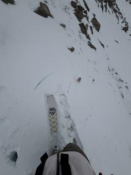
Wind slab avalanches are the primary concern through the weekend. They could break under the snow that fell yesterday or in the new snow that is going to fall and be blown around tomorrow and Sunday. Either way, they could easily have enough power to knock you off your feet and into the plethora of rocks and stumps that are still exposed with a thin, early season snowpack. Avoidance is the key as getting caught in an avalanche of any size is likely to result in traumatic injuries. Skiers yesterday in the northern Bridger Range triggered several small slides that demonstrate how surprising quickly even a thin slab can get snow moving (video). Wind drifts will be the largest and most dangerous in the areas with the most new snow (likely the Island Park area).
From public observations and our own limited fieldwork so far, the snowpack structure is looking pretty good for early season. Lots can still change, but for now, we’re cautiously optimistic about the lack of dramatic weak layers near the ground (Dave’s video from Beehive Basin).
With each snowfall, there are more slopes that have continuous snow cover and are more appealing to ski or ride. Unfortunately, these are exactly where you need to be most wary about avalanches. It is a cliche for a reason - if there is enough snow to ride, there is enough snow to slide. Tilt the odds in your favor watching for signs of instability (recent avalanches, crack, or collapsing), carrying rescue gear (beacon, shovel, and probe) and following safe travel protocols in and around avalanche terrain. If you’re not ready to shift into winter-mode and follow these safe travel practices, plan to avoid steep snow-covered slopes with more than a foot of snow.
Public observations are incredibly valuable as we develop a picture of the season's snowpack. Contribute to our community’s knowledge by submitting your observations, and look through our observation page for additional information before your next backcountry adventure.
Upcoming Avalanche Education and Events
Our education calendar is full of awareness lectures and field courses. Check it out: Events and Education Calendar
Tuesday, November 26, 6-7 p.m. Free Avalanche Awareness at REI Bozeman.
Monday, December 2, 6:30 p.m. MAP community partnership night and 1-hr Avalanche Awareness, at MAP Brewing
Tuesday, December 10, 9 a.m.-3 p.m., West Yellowstone Avalanche Fundamentals: Motorized Guide Cert Course, Pre-registration required.
For an intro class with a field day, Register for our Avalanche Fundamentals course.
Friends of the Avalanche Center: Fall Fundraiser!
We’re still counting on your support and the online Fall Powder Blast fundraiser is 76% of the way to our goal. Please consider making even a small donation HERE or via Venmo
Read accident reports from previous early-season accidents before you venture to the snowy hills. This accident report from October 2012 in the northern Bridger Range, and this report from the tragic fatality six years ago in early October are reminders of the potential consequences of even a small avalanche.


